
Platte River Priority Ecosystem Study
Platte Subprojects
- Sandhill Crane Infrared Video
- Channel Characteristics & Morphology
- Bathymetric LiDAR
- Geomorphic Monitoring of Habitat Enhancement Sites
Channel Characteristics and Morphology
The central Platte River Valley in Nebraska is an internationally significant staging area for migratory water birds of the Central Flyway and is best known for the one-half million sandhill cranes and the several million other waterfowl that migrate annually through the valley. Changes in water and land use have transformed the river channel (See Below) and altered adjacent wet meadows. With changes in the hydrology of the river and the structure of riparian habitats, the sustainability of migratory and resident birds and other biota have been brought into question. Of central concern is how the ecosystem has adjusted to changes in streamflow. Developing successful strategies to sustain or rehabilitate the riparian ecosystem of the central Platte River, requires an understanding of the linkages between hydrology, river morphology, biological communities, and ecosystem processes. Studies are categorized into elements. For more information about this interdisciplinary study visit the USGS Platte River Priority Ecosystem site. Researchers at the GSTL have been involved with the study elements listed below.
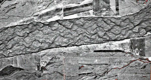
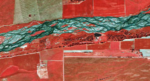
Comparison of 1951 aerial photo of the Platte River near Rowe Sanctuary, Nebraska, with a 1998 color infrared photo of the same site.
Element 4 --Channel Characteristics and Morphology
The interaction of vegetation and geomorphology near the channel banks is an important aspect of understanding the stability of the channel form. The resistance to erosion from vegetation is difficult to quantify, and measures to alter this resistance are complicated by interactions with streamflow magnitude and duration, local hydraulic conditions, and biotic factors. This interaction is examined by comparing detailed streamflow duration and hydraulic data to the vegetation communities in these sensitive areas near the channel boundary. Surveys of a limited number of bank segments, islands, and bars (See Below) will define the role of vegetation in stabilizing these landforms. This work will be augmented by prediction of local velocities and stress fields from the sediment-transport modeling.
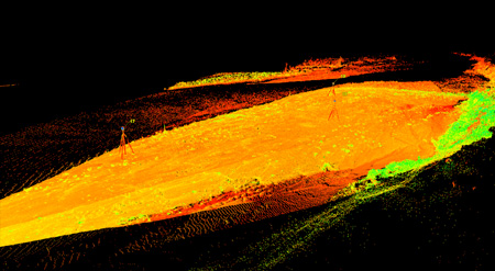
Color intensity image of a Platte River sandbar collected by Thad Wasklewicz (University of Memphis) using a 3-D laser scanner. Orange areas represent reflectance from sand surfaces and green areas those from vegetation.
Flow and Sediment-Transport Modeling
The use of multidimensional flow and sediment-transport models will assist in the understanding of potential channel changes that result from stream flow and manipulation of vegetation on islands and banks (See Below). Surveys of topography and grain-size distributions will be done to predict local sediment rating curves and critical flows for initiation of motion for grain sizes in both main and secondary flow channels. For a variety of real and hypothetical flow-discharge scenarios, model results will be used to make preliminary assessments of the role of hydrographs in maintaining or modifying channel and bank morphology. In addition, velocity and bottom stress maps of the critical reach will be compared to vegetation patterns to assess the roles of various flows in promoting or discouraging certain types of riparian vegetation.
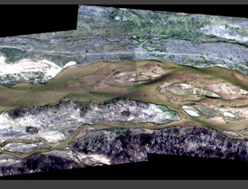
Aerial photograph of study site 3/2003.
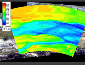
MD_SWMS topographic surface.
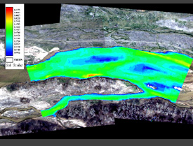
MD_SWMS computed depths (38 m3/s).
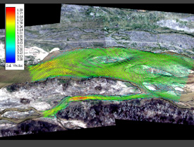
MD_SWMS computed velocity vectors (38 m3/s).
For More Information
Kinzel, P.J., Nelson, J.M., and Heckman, A.K., 2009, Response of sandhill crane (Grus Canadensis) riverine roosting habitat to changes in stage and sandbar morphology, River Research and Applications, 25: 135-152.
Kinzel, P.J., and Runge, J.T., 2010, Summary of bed-sediment measurements along the Platte River, Nebraska (1931-2009), U.S. Geological Survey Fact Sheet 2010-3087.