|
Channel Characteristics and Morphology
Investigations of channel morphology help to define and group characteristic reaches, provide a framework for examining the interaction of flow hydraulics and vegetation on banks and island bars, and identify critical reaches for more intensive study. This study element focuses on grouping reaches on the basis of flow and sediment characteristics, stability of the bed and banks of the channel, and biotic considerations. The physical characteristics of these reaches are identified by examining river profile, observing planiform and cross-section changes, analyzing stage-trends, and comparing hydraulic and sediment characteristics along the reach. This investigation relies on previously collected data.
The interaction of vegetation and geomorphology near the channel banks is an important aspect of understanding the stability of the channel form. The resistance to erosion from vegetation is difficult to quantify, and measures to alter this resistance are complicated by interactions with streamflow magnitude and duration, local hydraulic conditions, and biotic factors. This interaction is examined by comparing detailed streamflow duration and hydraulic data to the vegetation communities in these sensitive areas near the channel boundary. Surveys of a limited number of bank segments, islands, and bars will define the role of vegetation in stabilizing these landforms. This work will be augmented by prediction of local velocities and stress fields from the sediment-transport modeling.
 |
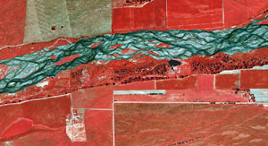 |
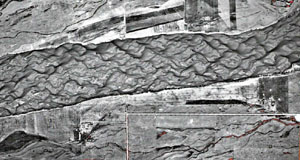
| Comparison of 1951 aerial photo of the Platte River near Rowe Sanctuary, Nebraska, with a 1998 color infrared photo of the same site |
Flow and Sediment-Transport Modeling
The use of multidimensional flow and sediment-transport models will assist in the understanding of potential channel changes that result from stream flow and manipulation of vegetation on islands and banks. Surveys of topography and grain-size distributions will be done to predict local sediment rating curves and critical flows for initiation of motion for grain sizes in both main and secondary flow channels. These surveys resolve topographic variability in the channel itself at 2-cm vertical resolution or better, and horizontal variability is characterized with centimeter-scale accuracy. At the same location, detailed grain-size surveys will be carried out to characterize spatial and vertical (at-a-point) variability in sediment grain sizes. For a variety of real and hypothetical flow-discharge scenarios, model results will be used to make preliminary assessments of the role of hydrographs in maintaining or modifying channel and bank morphology. In addition, velocity and bottom stress maps of the critical reach will be compared to vegetation patterns to assess the roles of various flows in promoting or discouraging certain types of riparian vegetation.
 |
 |
|
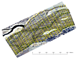
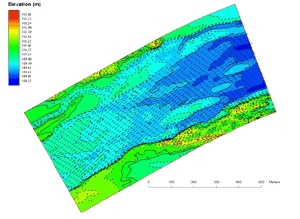
GPS Topographic Survey, Rowe Sanctuary, Nebraska, and output from a 2-dimensional hydraulic model showing velocity vectors along the study reach
|
|