 (188k) (188k)
|
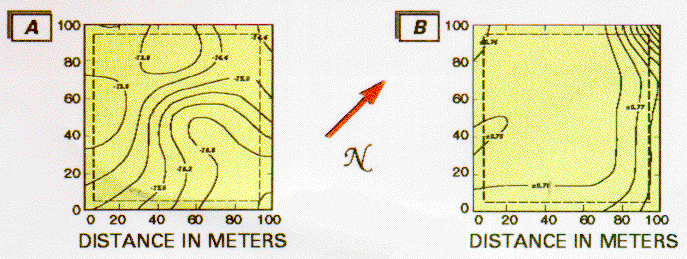
Contour maps of snow grid surface showing kriged estimate of
![]() 18O values in permil (A) and the one sigma uncertainty
associated with the estimate in permil (B). Contour interval is 0.6
permil for Map A and + 0.01 permil for Map B. The dashed area within
each map represents the boundary of the original 8,100 m2
snow grid. The data were block kriged by using 25 square blocks of
equal area. A maximum of 30 samples was used to estimate each block.
One hundred samples were collected within the grid area in August 1991.
18O values in permil (A) and the one sigma uncertainty
associated with the estimate in permil (B). Contour interval is 0.6
permil for Map A and + 0.01 permil for Map B. The dashed area within
each map represents the boundary of the original 8,100 m2
snow grid. The data were block kriged by using 25 square blocks of
equal area. A maximum of 30 samples was used to estimate each block.
One hundred samples were collected within the grid area in August 1991.

