
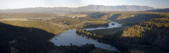
Kootenai River
The Kootenai River white sturgeon population is physically isolated and
genetically distinct from other white sturgeon populations in the Columbia River
(Setter and Brannon 1990). Following the completion of Libby Dam in Montana,
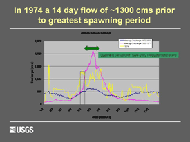
during 1972, the only year of significant recruitment in the population occurred
in 1974, one year prior to full power plant operation in 1975. During subsequent
years, a small number of naturally produced juvenile fish have been found but
their abundance is too low to sustain the population. In 1994 the Kootenai
 River white sturgeon population was listed as endangered (USFWS 1994). Further
protection was obtained in 2001 through the designation of 18 river kilometers (rkm)
of Critical Habitat downstream from Bonners Ferry, Idaho (rkm 228- 246) (USFWS
2001). Monitoring locations of adult white sturgeon through telemetry studies
and inferring general spawning locations from egg collections has consistently
shown this reach to be the main region of spawning (Paragamian and others, 2001).
River white sturgeon population was listed as endangered (USFWS 1994). Further
protection was obtained in 2001 through the designation of 18 river kilometers (rkm)
of Critical Habitat downstream from Bonners Ferry, Idaho (rkm 228- 246) (USFWS
2001). Monitoring locations of adult white sturgeon through telemetry studies
and inferring general spawning locations from egg collections has consistently
shown this reach to be the main region of spawning (Paragamian and others, 2001).
 White sturgeon spawn by broadcasting their eggs which become adhesive shortly
after exposure to water (Scott and Crossman 1973; Conte and others, 1988). Where
successful spawning occurs in other river systems, eggs are assumed to attach to
or settle into interstitial spaces provided by coarse substrates such as gravels
and cobbles (Parsley and others, 1993; Parsley and others, 2002). Successful spawning of
Kootenai River white sturgeon occurs annually within the critical habitat reach,
confirmed by the annual presence of viable eggs and developing embryos (Paragamian
and others, 2001). However, the river substrate under most flow conditions in the
critical habitat reach is predominantly composed of fine sand with large
migrating dunes (Barton 2004). Spawned eggs are presumed to settle onto the bed,
and may become covered in the fine sand, or buried in the trough of migrating
dunes resulting in suffocation and/or predation. Interestingly, within a few
kilometers upstream from the spawning locations, the river is braided,
relatively shallow, and has suitable substrate composed mostly of gravel and
cobble.
White sturgeon spawn by broadcasting their eggs which become adhesive shortly
after exposure to water (Scott and Crossman 1973; Conte and others, 1988). Where
successful spawning occurs in other river systems, eggs are assumed to attach to
or settle into interstitial spaces provided by coarse substrates such as gravels
and cobbles (Parsley and others, 1993; Parsley and others, 2002). Successful spawning of
Kootenai River white sturgeon occurs annually within the critical habitat reach,
confirmed by the annual presence of viable eggs and developing embryos (Paragamian
and others, 2001). However, the river substrate under most flow conditions in the
critical habitat reach is predominantly composed of fine sand with large
migrating dunes (Barton 2004). Spawned eggs are presumed to settle onto the bed,
and may become covered in the fine sand, or buried in the trough of migrating
dunes resulting in suffocation and/or predation. Interestingly, within a few
kilometers upstream from the spawning locations, the river is braided,
relatively shallow, and has suitable substrate composed mostly of gravel and
cobble.
Successful spawning and recruitment of Kootenai River white sturgeon involve complicated
biological and ecological processes that may be affected by hydraulic and
sediment-transport characteristics. Several hypotheses relating to the hydraulic
and sediment transport characteristics of the Kootenai River have been put forth
as possible explanations to
 the decline of successful recruitment in this system
(Duke and others, 1999). First, in the post-dam period, the loss of naturally
occurring high spring flow in addition to lower Kootenay Lake stages may have
shifted the hydraulic spawning farther downstream into the current spawning
reach. Prior to Libby Dam, higher lake levels or greater backwater extent and
river stage may have encouraged the fish to spawn farther upstream in the
braided reach. Second, the higher pre-dam discharge may have mobilized and
scoured the bed sufficiently in the existing spawning reach to expose
coarse-grained substrate suitable for egg hatching, and provided deeper water
for upstream migrations areas that are very shallow in the post-dam era.
However, it is likely that factors in addition to physical habitat alterations
contribute to recruitment limitation and failure.
the decline of successful recruitment in this system
(Duke and others, 1999). First, in the post-dam period, the loss of naturally
occurring high spring flow in addition to lower Kootenay Lake stages may have
shifted the hydraulic spawning farther downstream into the current spawning
reach. Prior to Libby Dam, higher lake levels or greater backwater extent and
river stage may have encouraged the fish to spawn farther upstream in the
braided reach. Second, the higher pre-dam discharge may have mobilized and
scoured the bed sufficiently in the existing spawning reach to expose
coarse-grained substrate suitable for egg hatching, and provided deeper water
for upstream migrations areas that are very shallow in the post-dam era.
However, it is likely that factors in addition to physical habitat alterations
contribute to recruitment limitation and failure.
The goal of this study is to use the results of a preliminary set of 2D computational flow simulations within the 18-kilometer Critical Habitat reach to: (1) gain insight into the hydraulic conditions in the spawning reach, (2) assess whether these hydraulic conditions serve as spawning cues, (3) assess the effects of flow management (Kootenay Lake Stage and Libby Dam discharge) on those cues, and (4) gain insight into the role of pre- and post-dam flows in regulating the sediment substrate characteristics in the spawning reach.
Videos
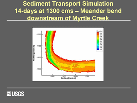
Sediment transport simulation, 14 days at 1300 cms, meander bend downstream of Myrtle Creek.
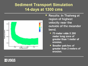
Sediment transport simulation, 14 days at 1300 cms.