
Alaska Rivers Sediment Transport
GSTL staff, including Jon Nelson and Rich McDonald, are working closely with the USGS Alaska Science Center to support the use of the MD_SWMS modeling interface with ongoing projects including:
- Modeling and Monitoring Streambed Scour at Alaska Bridges with Jeff Conaway. See McDonald and others, 2006; and Conaway and Moran, 2004.
- Lower Copper River Dynamics and Geomorphology Project with Tim Brabets.
Example from Knik River: High resolution scour data from the Knik River will be used for validating the Sediment Transport and Channel Evolution modules currently in development for use in MD_SWMS.
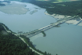
Knik River near Palmer, Alaska. Flow is from right to left.
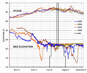
Knik Scour monitoring data 2002-2005. Streambed elevation is measured every 30 minutes.
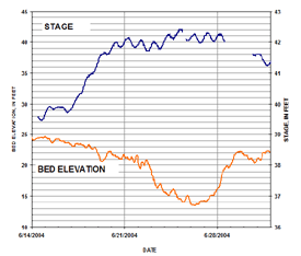
Knik Scour monitoring data during high scour event in 2004.
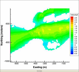
Simulated streamwise velocity magnitude during 2004 scour event.
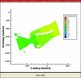
Simulated Water Surface Elevation during 2004 scour event.
References
McDonald, R., Nelson, J., Kinzel, P., Conaway, J., 2005, Modeling Surface-Water Flow and Sediment Mobility with the Multi-Dimensional Surface-Water Modeling System (MD_SWMS): U.S. Geological Survey Fact Sheet 2005 – 3078, 6 p.
Conaway, J.S., and Moran, E.H., 2004, Development and calibration of a two-dimensional hydrodynamic model of the Tanana River near Tok, Alaska: U.S. Geological Survey Open-File Report 2004-1225, 13 p.