
Flow, Sediment Supply, and Riparian Vegetation
Improved understanding of how physical processes affect biological resources in rivers is needed both to increase basic knowledge of riverine ecosystems and to buttress the scientific basis of river management and restoration. As part of Andrew Wilcox’s post-doctoral research with GSTL, we are investigating the interacting effects of changes in flow, sediment, and riparian vegetation on channel form and aquatic habitat. These issues are being investigated using flume modeling, computational modeling, and field studies on rivers where dams have altered flow and sediment regimes and vegetation dynamics.
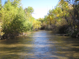
One such field study investigates the geomorphic and vegetation response to a
controlled flood release on the Bill Williams River (BWR), Ariz., in collaboration
with Patrick Shafroth (USGS,Biological Resources Division). In March 2006, a controlled flood was
released from Alamo Dam, an Army Corps of Engineers facility 55 km upstream from where the
Bill Williams River enters Lake Havasu on the Colorado River. The flood release of 56
m3/s for two days, followed by a gradual daily drawdown of approximately 1 m3/s,
although small compared to historic floods on the BWR, was designed with input
from scientists to investigate the hydrograph characteristics needed to
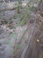
promote establishment of native riparian vegetation (primarily cottonwood and
willow), to cause mortality of young tamarisk, and to affect geomorphic changes
associated with vegetation responses. The BWR is of particular interest because,
despite the presence of tamarisk, it is characterized by a high quality native
riparian ecosystem and associated bird communities. The BWR study has entailed
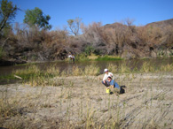
detailed field data collection
 on two study reaches before, during, and after the March 2006 flood release.
Data collection included topographic surveys using survey-grade GPS, bed
sediment sampling, installation of scour chains, vegetation monitoring, and
velocity and stage measurements during the flood. Field data on geomorphic and
ecological changes caused by the flood are being complemented by modeling using
the Multidimensional Surface Water Modeling System (MD_SWMS), pre-flood LiDAR
data, and previous aerial photograph interpretation by Shafroth. These analyses
are being used to assess relationships between hydrograph characteristics,
channel morphology, shear stress patterns, and vegetation response.
on two study reaches before, during, and after the March 2006 flood release.
Data collection included topographic surveys using survey-grade GPS, bed
sediment sampling, installation of scour chains, vegetation monitoring, and
velocity and stage measurements during the flood. Field data on geomorphic and
ecological changes caused by the flood are being complemented by modeling using
the Multidimensional Surface Water Modeling System (MD_SWMS), pre-flood LiDAR
data, and previous aerial photograph interpretation by Shafroth. These analyses
are being used to assess relationships between hydrograph characteristics,
channel morphology, shear stress patterns, and vegetation response.
In addition, we will use physical modeling in the GSTL flume laboratory to investigate how interactions between flow, sediment supply, and vegetation affect physical and biological processes. This will entail flume experiments testing the effect of varying levels of flow, sediment supply, and vegetation density on channel bed morphology, sediment transport, and vegetation mortality. One objective of this work is to evaluate the relative influence of different hydrograph components (e.g., magnitude versus duration versus rate of change) on morphologic and vegetative responses in an effort to improve the quantitative basis for ecosystem flow prescriptions on dammed rivers. Our flume experiments will complement previous and ongoing studies of vegetation effects on geomorphic processes at St. Anthony Falls and UC-Berkeley.