
Geomorphic Monitoring of Habitat Enhancement Sites
Platte Subprojects
- Sandhill Crane Infrared Video
- Channel Characteristics & Morphology
- Bathymetric LiDAR
- Geomorphic Monitoring of Habitat Enhancement Sites
Cottonwood Ranch Property
This project is intended to restore and enhance river roosting habitat for the endangered whooping crane and sandbar habitat for the endangered least tern and piping plover. This project involves removing vegetation from the riparian corridor to increase the unobstructed width of the river for roosting cranes. At the same time two islands were cleared of vegetation to provide potential nesting habitat for tern and plovers. The USGS with funding from the Platte River Endangered Species Partnership is monitoring the local and downstream geomorphic effects of vegetation clearing at this site.
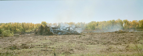
Clearing and burning of riparian trees in the Nebraska Public Power District's Cottonwood Ranch Property - 10/2002.
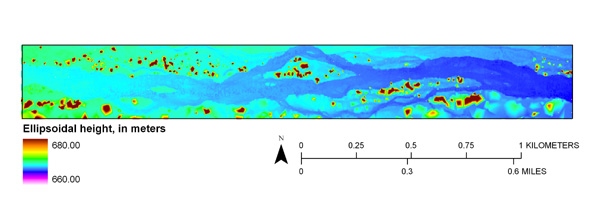
LiDAR surface of a reach of the Platte River passing through the Cottonwood Ranch Property collected 3/2002 before habitat development activities (trees are colored red).
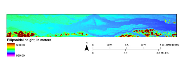
LiDAR surface of a reach of the Platte River passing through the Cottonwood Ranch Property collected 6/2005 following the habitat development activities (trees are colored red).
Uridil Property
This project is specifically intended to restore and enhance sandbar habitat for the endangered least tern and the threatened piping plover along the Big Bend reach of the Platte River, Nebraska, but the project should also benefit a host of other species including the endangered whooping crane. The project involves a technique that removes sediment from the tops of relatively high, semi-permanent sandbar islands, and places this sediment into the active river channel. This technique immediately removes the visual obstruction to water birds from these high islands, while the sediment becomes available for average river flows to form and erode new lower sandbars. The USGS with funding from the Nebraska Environmental Trust Fund is monitoring the local and downstream geomorphic effects of the sediment augmentation at this site.
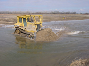
Sediment augmentation in the Platte River Whooping Crane Maintenance Trust's Uridil Property - 2/2006.
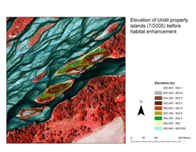
Topographic surveys of Uridil island sites before habitat enhancement.
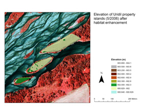
Topographic surveys of Uridil island sites after habitat enhancement.
For More Information
Kinzel, P., 2009, Channel morphology and bed sediment characteristics before and after habitat enhancement activities in the Uridil Property, Platte River, Nebraska, Water Years 2005-2008: U.S. Geological Survey Open-File Report 2009-1147, 23 p.
Kinzel, P., 2008, River channel topographic surveys collected prior to and following elevated flows along the central Platte River, Nebraska, Spring 2008: U.S. Geological Survey Data Series Report 2008-380, 10 p.
Kinzel, P., Nelson, J., and Heckman, A., 2006, Channel morphology and bed sediment characteristics before and after riparian vegetation clearing in the Cottonwood Ranch, Platte River, Nebraska, Water Years 2001-2004: U.S. Geological Survey Scientific Investigations Report 2005-5285, 25 p.
Kinzel, P., Parker, R., Nelson, J., Gyetvai, S., Burman, A, and Heckman, A., 2005, Geomorphic data collected within Nebraska Public Power District’s Cottonwood Ranch Property, Platte River, Nebraska, Water Year 2004: U.S. Geological Survey Open-File Report 2005-1090, 23 p.
Kinzel, P., Parker, R., Nelson, J., Gyetvai, S., Burman, A, and Heckman, A., 2004, Geomorphic data collected within and adjacent to Nebraska Public Power District’s Cottonwood Ranch Property, Platte River, Nebraska, Water Year 2003: U.S. Geological Survey Open-File Report 2004-1292, 25 p.
Kinzel, P., Parker, R., Nelson, J., Gyetvai, S., Burman, A, and Heckman, A., 2003a, Geomorphic data collected within and adjacent to Nebraska Public Power District’s Cottonwood Ranch Property, Platte River, Nebraska, Water Year 2002: U.S. Geological Survey Open-File Report 2003-171, 19 p.
Kinzel, P., Parker, R., Nelson, J., Gyetvai, S., Burman, R., and Heckman, A., 2003b, Geomorphic data collected within and adjacent to Nebraska Public Power District’s Cottonwood Ranch Property, Platte River, Nebraska, Water Year 2001: U.S. Geological Survey Open-File Report 2003-170, 19 p.